This article reviews two orientation tools that are based on global positioning satellite (GPS) technology: VisuAide's Trekker and Sendero Group's GPS product, which runs on Pulse Data's BrailleNote and VoiceNote personal digital assistants (PDAs). GPS technology is now widely available as a navigation aid for drivers. GPS systems also have enormous potential for assisting people who are visually impaired in navigating. One of the greatest benefits of using an accessible GPS system is the ability to explore your environment. Knowing information, such as which streets intersect and the name of the restaurant you are passing, can be extremely helpful. The two systems evaluated here finally bring GPS technology to devices that are small enough to be carried around and operated comfortably. It's important to remember, however, that GPS receivers have to have a direct line of sight with one or more of the 24 GPS satellites in orbit around the Earth to receive GPS data. The devices will not function indoors or when surrounded by tall buildings.
Both products use commercial databases that are filled with points of interest, such as gas stations, restaurants, tourist attractions, and automatic bank teller (ATM) locations. They also use mainstream GPS receivers that communicate with satellites in orbit around the Earth to pinpoint where you are. We tested both systems and point out their strengths and weaknesses.
Trekker 2.0
Physical Description
Trekker consists of an off-the-shelf personal digital assistant, a GPS receiver, a speaker, and a battery pack. These four pieces are attached to a strap that is worn around the neck. Trekker weighs 1.3 pounds and comes with documentation and accessories, including a PDA charger, a PDA cradle or base, PDA styli, keyboard static stencils (for the braille keyboard), and a user guide. The packaging for this version is sturdier than the previous version, reviewed in the July 2003 issue of AccessWorld, especially the PDA's case and the metal hooks that attach the PDA to the strap.
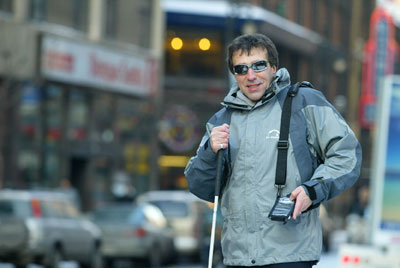
Caption: The Trekker.
The On/Off button for the PDA is located above the PDA screen. There is no audible feedback to tell you whether the PDA has been turned off, although pressing the button that runs the Trekker program also turns on the PDA. Trekker is a self-voicing application that runs on the PDA, using Eloquence as its synthesizer. No other applications on the PDA are currently accessible.
Trekker's controls consist of four round buttons, two on each side of a much larger, oval-shaped Navigation key. The Navigation key serves as a cursor cross and is used for navigating Trekker's menus. To the right of the Navigation key are the Enter button, used for running the Trekker program, opening menus, and responding to queries from Trekker, and the Where Am I? button, which provides information about your current location. To the left of the Navigation key are the Escape button and the Mode button, which toggles between Trekker's reading and browsing modes.
When you turn Trekker on, it begins searching for satellites to provide the information needed to announce your location. You hear a series of beeps during the satellite search. When a GPS signal is received, usually in two to three minutes, Trekker announces the name of the street on which you are walking. When you are about 30 feet from an intersection, Trekker describes the intersection, for example, "Four-way intersection, Queens Boulevard crossing Ascan Avenue."
The unit contains points of interest from a commercial database, including restaurants, banks, schools, and gas stations. When you arrive near one of these locations Trekker announces it; for instance, "Citibank, on your right." (This feature can be turned off if desired.) You can add your own points of interest to the list using the microphone built into the PDA. You press the Record button, on the left side of the PDA, and speak your message. You must make the initial recording at the location, such as at the entrance to a train station, but you can edit the recording later to provide a longer description of the location. Since Trekker uses a commercial database, the emphasis is on places that would interest drivers. Many local stores are omitted and must be entered by the user.
During testing, announcements of points of interest were inconsistent. Typically, a point was identified one out of every two times the tester passed it. Announcements of intersections were more consistent. However, Trekker sometimes announced the "next" intersection after the tester had begun crossing the street or even after he finished crossing it. Both these problems are explained by the fact that, for civilian use, GPS is accurate only down to about 30 feet. But this fact emphasizes the point that GPS devices are just a supplement to a cane or a dog guide.
The Menus
You open Trekker's menus by pressing the Enter button and move from menu to menu by pressing the Navigation key. The Points of Interest menu allows you to search for, create, edit, or delete points of interest.
The Search function lets you type in the name of a point of interest or select from a list of more than 50 categories, including restaurants, tourist attractions, banks, hotels, and bowling centers. Typing in a name requires the use of a keyboard composed of 12 buttons, in 3 vertical rows of 4 keys each, on the front panel of the PDA. VisuAide has adapted these buttons so that 3 buttons in the left-most column represent dots 1, 2, and 3 of a braille cell, and 3 buttons on the right represent dots 4, 5, and 6. So, to type the letter R, you press dot 1, dot 2, dot 3, dot 5, and then the Enter button in the middle column on the braille keyboard. No contractions are allowed. Needless to say, this process is tedious, especially for typing long names, and is one of the drawbacks of adapting an off-the-shelf PDA. (The advantage of using an off-the-shelf PDA is a lower price.) If you do not know braille, you can choose the telephone keypad to enter data.
In the Info menu, you can find out how many satellites your receiver is currently tracking, hear the current time, and find out your current location, which you also get by simply pressing the Where Am I? button. The System option in this menu gives information, including battery level, the version of Trekker, space remaining on the flash card, and so on.
The Settings menu contains options to turn the GPS on or off and to adjust the amount of information and prompting Trekker provides: general settings, such as voice rate and volume and backlight control for the PDA screen. There is also a volume control on the speaker on Trekker's strap. In the Help menu, you will find Getting Started and Quick Reference files. These files do a good job of orienting a new user and getting you going with Trekker.
In addition to Pedestrian mode, used when you are walking, Trekker now works in Motorized mode, when you are traveling in a car, and in Free mode, used in open spaces, such as parks or parking lots. So, you can create a point of interest at a park bench, and Trekker will guide you back to near that point. These two new modes, along with the "Browsing Offline" mode, are found in the Tools menu. In contrast with pedestrian mode, Motorized mode worked consistently, with Trekker announcing intersections as or soon before they were crossed. Browsing offline allows you to explore a neighborhood before you actually travel there. This option lets you explore an unfamiliar area or plot your route.
The most significant addition to Trekker 2.0 is the ability to plot and follow a route. The Route submenu lets you choose a starting point and a destination. Trekker will then guide you from Point A to Point B. The easiest way to do so is to choose your last GPS location as the starting point and one of the points of interest you entered previously as the destination. For example, you can use your home as the starting point and choose your favorite restaurant as the destination. Trekker will compute the route and guide you to the destination. While you are traveling the route, Trekker announces whether you are "on route" or "off route" and how far you are from your destination and alerts you to the next turn you have to make.
If you want to travel from where you are to the Empire State Building, you can either type in "Empire State Building" on the keyboard or search the Tourist Attractions category. Such a search will usually bring up 500 possible points in alphabetical order. You then have to arrow down, using the Navigation key, to "Empire State Building." You can limit the number of items found using this type of search by choosing to restrict the search to, for example, "five minutes"—that is, five minutes in driving time from your location. This is the most useful way to restrict a search, since many points in the commercial database do not have a city or zip code attached to them. So, if you enter a city name or zip code, you are likely to get no results. The map used for this test included all of New York City.
In the Route menu, you can activate, create, deactivate, delete, edit, and reverse routes. So, after finding your way to the Empire State Building, you can reverse the route and retrace your steps to your hotel.
The Bottom Line
Trekker version 2.0 is a much more attractive product than the first version we evaluated in the July 2003 issue of AccessWorld. You can now adjust the speech rate and, what is more important, use the maps to plan and follow routes that you travel regularly or just once. Trekker's drawbacks are the clumsy way you must enter any data on the keyboard, the fact that you have to navigate over and over through the menus (since Trekker exits the menus when you choose most options), and the fact that a person who is visually impaired can never be sure that the PDA is turned off and is not using up the battery. These drawbacks are all related to using an off-the-shelf PDA. The advantage of this approach is that the price can be kept relatively low. We would like to have Trekker announce the direction in which we are traveling and be more consistent in announcing points of interest.
BrailleNote GPS
The BrailleNote GPS system consists of a GPS receiver and software that can be loaded on any of Pulse Data's BrailleNote or VoiceNote series of products. Using this powerful orientation tool, you can plan routes, determine your current location and direction of travel, and locate nearby points of interest. These points of interest can be any one of thousands of predefined points like restaurants, hotels, and other local businesses. The BrailleNote GPS system can also store user-defined points, such as bus stops or businesses that are not included in the commercial database of predefined points.

Caption: The BrailleNote GPS system consists of a BrailleNote or VoiceNote personal organizer and a cell phone-sized receiver.
What Is in the Package?
BrailleNote users have the option of purchasing the GPS system in one of two ways. The first and less expensive option includes all the map data on CD-ROM. A 256-megabyte compact flash storage card is included, so you can copy the data you want on the card. This card can hold several states' worth of map and points-of-interest data. The second option includes a 1-gigabyte card. This card can hold more state maps, but maps for all 50 U.S. states would require 5.5 gigabytes.
The folders for the CDs containing maps have braille labels, and the documentation, including audio tutorials, is also on CD. The command lists are in braille and print, and a braille manual can be purchased. Both options include a cell phone–sized GPS receiver that attaches to the BrailleNote via a serial port. When the product is shipped, the serial cable is not connected to the receiver. We found the process of connecting this cable to be a bit tricky, and it is not well documented. The package also includes software that must be installed on the BrailleNote. Experienced BrailleNote users should have no problems performing this task.
The Receiver
The front of the BrailleNote GPS system's cell phone-sized receiver contains seven small rubber buttons and one large round button. Only two of these buttons are useful to BrailleNote GPS users. The bottom-right button turns the receiver on and off. There is no audible indication when the product is switched on or has a low battery. A button on the bottom left corner is used to turn a light on within the receiver's display. When this light is on, the device makes a faint buzzing sound. Turning this light on and off and carefully listening for the buzzing sound is the only way for a person who is visually impaired to know if the receiver itself is on or off. This process is described in the tutorial that is shipped with the product, but the tutorial is not good enough, especially for new users.
The GPS receiver is hooked to the BrailleNote via the serial port. The cord that leads from the GPS receiver can be stored using the shoulder strap on the BrailleNote; there is a long strip of Velcro that will hold the wire so that it does not hang down. The receiver can also be attached to the strap via the Velcro strips on the strap and side of the receiver's case. During our evaluation, we found that the receiver was much more secure when it was attached to the strap by the clip on the side of the case. Even with the receiver firmly in place, walking around carrying the BrailleNote receiver and strap can be a bit bulky and takes some practice before it can be done comfortably and efficiently.
Exploring Your Environment
The BrailleNote GPS system provides several methods for its users to explore their environment. The product has a Look Around mode, which works indoors and outdoors. When this mode is active, BrailleNote automatically announces and displays the name of any points of interest within a specified distance from your current location. Even if Look Around mode is not activated, this information is just a single keystroke away. The product can also be set to inform you of the name of upcoming intersecting streets.
If you want to explore without all the legwork, BrailleNote GPS offers a powerful virtual mode. Using the virtual mode, you can locate an address, find points of interest that are near that address, or plan a route to another address. The latest version of the system, version 3.0, incorporates an Explorer mode. For those who used the old Atlas Speaks software from Arkenstone, Explorer mode will be familiar and a welcome return. Using keystrokes on the BrailleNote, you can virtually explore an area using Explorer mode. One keystroke, for example, moves your virtual position one block forward. Another keystroke will allow you to turn right or left 90 degrees virtually. Using these keystrokes, you can traverse any area to find intersections or addresses. Explorer mode can be used only in the virtual mode. It gave us the opportunity to study an environment before we walked around in it.
When the BrailleNote GPS system is used in an outdoor environment, it offers a variety of commands to give you information. Information, such as your current direction and speed of travel, the current altitude, and the closest address, can all be obtained with a single keystroke. Since many users will use this product while walking, Sendero has endeavored to make several of the more frequently used commands available with a keystroke that requires only one hand. Even so, learning how to control and gather information from the product while concentrating on information provided by your cane or guide dog takes some practice.
Another useful feature of the system is the ability to plan a route automatically. Once a route has been calculated, the BrailleNote can advise you of the next turn in the route, the total distance of your route, and the distance to the end of the route. Routes can be saved and reloaded the next time you want to travel to the same location. We did find that planning and using routes was not well documented, however.
How It Worked
During our evaluation, the BrailleNote system was used in different settings for a variety of tasks. In a small downtown area, we located a specific address and plotted a route to a second address. During this trip, we found that the system had great variations in its accuracy. It is true that the GPS system is only as good as the signal it receives from the GPS satellites. While you are using the unit, a keystroke can be pressed at any time that will inform you of the current status of satellite reception. Even when reception was excellent and the receiver was communicating with seven satellites, the system told us several times that we were approximately 500 feet from an address when, in fact, we were directly in front of it. This variation was not consistent, even when we used the same address. This lack of consistency could be a problem for users who are visually impaired.
We also used the product in a wide, open park. In this test, we set a series of way points—essentially, dropping electronic bread crumbs—and attempted to navigate back to their exact location. The system is much more accurate in finding way points than it is in finding points of interest. We found that the accuracy improved the farther the different way points were from each other. So, a way point that was 500 feet from the next closest way point was found more accurately than a way point that was only 100 feet from a neighboring point. When conducting both these tests, we found that the system worked much better when we walked at a steady and consistent rate of speed, such as 3 miles per hour.
Finally, we evaluated the system while riding in a car. This was probably the most productive of our product tests. The Look Around feature allowed us to learn the location of businesses as we passed them. Not all major businesses were announced, but this is undoubtedly a problem with the map data. The BrailleNote GPS also did a great job of conveying the name of the current road being traveled and our direction and rate of speed on that road. All this information was both spoken and displayed in braille.
The Bottom Line
The BrailleNote GPS system is a great tool to use for orienting yourself to a new environment or learning about the current environment. The Look Around feature and Explorer mode are useful additions to the product. The inaccuracy of points of interest is an issue, but it is an issue you can learn to account for in your daily travels. The product is not, nor does it claim to be, a replacement for a primary mobility tool, such as a white cane or a guide dog. Rather, it is a tool for gaining useful information about a particular area. For users of the BrailleNote series of products who are considering adding an accessible GPS solution, we would encourage you to take a look at the BrailleNote GPS product.
Manufacturer's Comments
VisuAide
"We would like to thank AccessWorld for reviewing Trekker and for letting more users know about our products. As is mentioned in the article, GPS does not provide an absolute position, but we are confident that it will keep improving with planned evolutions in the satellites and receivers. VisuAide is busy working on Version 3 of Trekker that will address the issues raised in this article. In addition, we would like to mention the launch of Maestro by VisuAide this past July that allows users to have access to more functions on the PDA (agenda, contacts, vocal and text notes). Maestro provides a tactile screen interface that makes it easier to enter information than does Trekker. Maestro can be bought as an addition to Trekker for $300."
Sendero Group
"A Beta version of the BrailleNote GPS Version 3 was provided to AFB for review. Accessible manuals are available as well as an audio tutorial. Optional GPS courseware can be purchased.
"One of the benefits of the BrailleNote GPS is that we can upgrade to the state-of-the-art receiver at any time. The review was based on an older model receiver and is incorrect on a number of points. The current Earthmate is 2 inches square and better in performance and convenience.
"Many years of feedback from blind users of Sendero's GPS products means the BrailleNote GPS has a depth of features not able to be covered in this review nor available in other recent GPS products. A complete list of features and Version 3 changes are available on the SenderoGroup.com site."
View the Product Features as a graphic
View the Product Features as text
View the Product Ratings as a graphic
View the Product Ratings as text
Product Information
Product: Trekker
Manufacturer: VisuAide, 841, Jean-Paul-Vincent, Longueuil, Quebec, Canada, J4G 1R3; phone: 888-723-7273 or 450-463-1717; e-mail: <info@visuaide.com>; web site: <www.visuaide.com>.
Price: $1,595.
Product: BrailleNote GPS
Manufacturer: (GPS software) Sendero Group, 1118 Maple Lane, Davis, CA 95616-1723; phone: 530-757-6800; e-mail: <gps@senderogroup.com>; web site: <www.senderogroup.com>.
Manufacturer: (BrailleNote): Pulse Data HumanWare, 175 Mason Circle, Concord, CA 94520; phone: 800-722-3393 or 925-680-7100; fax: 925-681-4830; e-mail: <info@humanware.com>; web site: <www.pulsedata.com>.
Price: $1,099, $1,049 with 256 MB compact flash, and $1,399 with 1 GB compact flash.